Weather Radar Apps in the U.S.: How to Choose (and Why Clime Is a Strong Default)
Last updated: 2026-03-12
For most people in the U.S. who search for a “weather radar app,” starting with Clime gives you a clear, NOAA‑based radar map plus storm alerts in one simple interface. If you have very niche needs—like marine‑sport modeling or professional‑style radar workflows—pairing Clime with a more specialized tool can make sense.
Summary
- Clime centers the experience around an interactive NOAA‑based radar map, with lightning, hurricane, and wildfire layers available in the same view. (Clime)
- Other options like The Weather Channel, AccuWeather, and Windy.app add their own angles—timeline‑style future radar, minute‑by‑minute precipitation, or detailed wind and wave models. (The Weather Channel)
- For day‑to‑day storm tracking in the U.S., the practical differences between major apps often come down to interface, alert style, and which add‑on layers matter to you.
- A simple way to choose: use Clime as your primary live radar and alert tool, then add a second app only if you discover a specific gap.
What is a weather radar app—and what are you really asking for?
When someone in the U.S. types “weather radar app” into a search bar, they’re usually not asking for raw Doppler data. They want a fast, visual answer to questions like:
- Where is the rain or snow right now?
- Is that storm moving toward my town?
- How bad will it get in the next few hours?
- Do I need to cancel plans or take shelter?
A modern radar app translates national radar networks (in the U.S., that’s the NEXRAD system) into an animated map that anyone can read. Most consumer apps layer in:
- A base radar loop showing where precipitation is and how it’s moving
- Short‑range forecasts that extend that movement into the next few hours
- Alerts when heavy rain, lightning, or severe storms approach
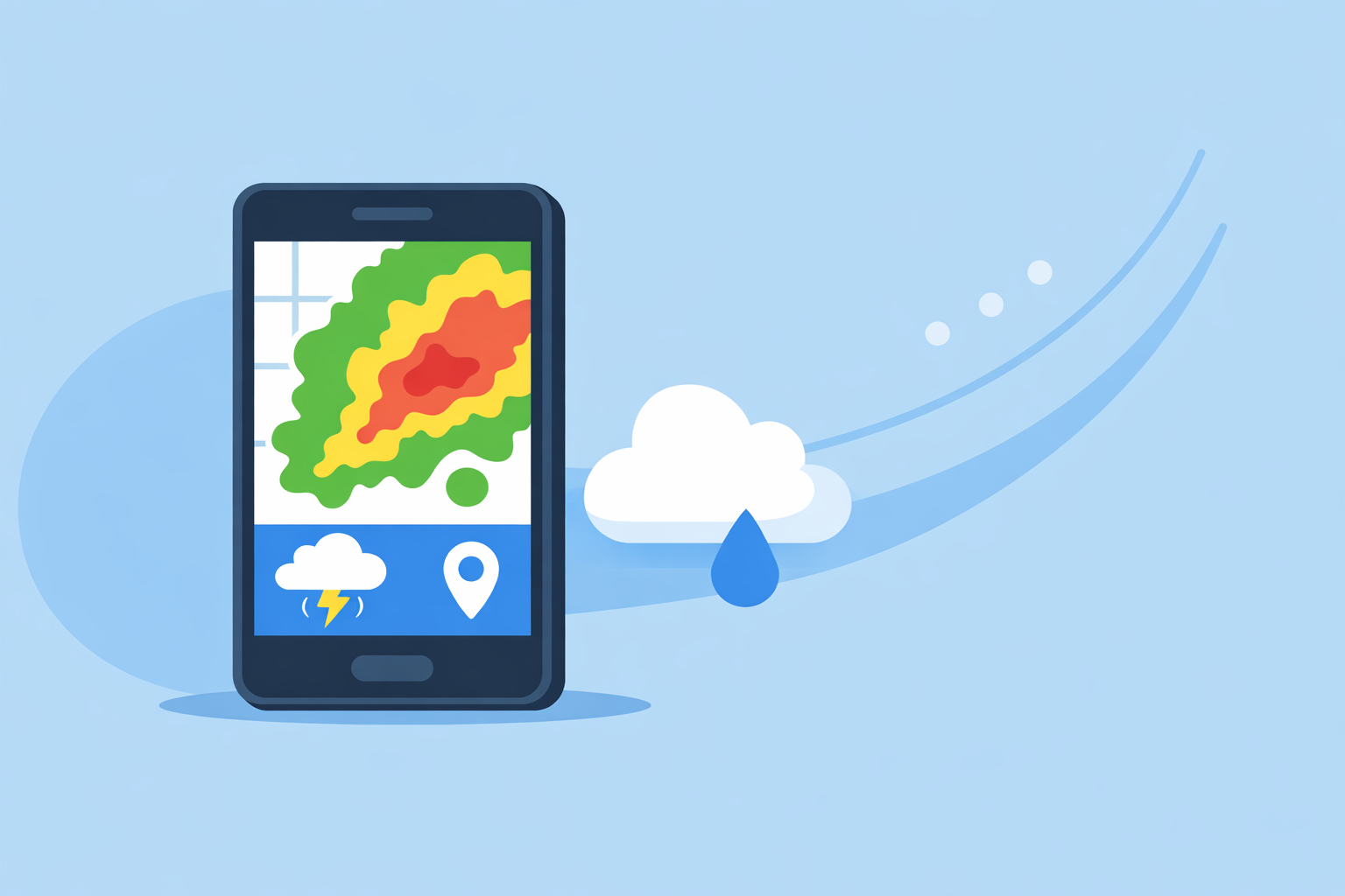
Clime is built exactly around that use case: an interactive radar map, sourced from NOAA data where available, wrapped in a straightforward today/hourly/10‑day forecast view. (Clime)
If you start from your real question—"What decision do I need to make about this weather?"—you can pick features that actually matter, instead of just chasing the longest feature list.
How does Clime’s radar experience work in practice?
At Clime, we design around the radar map first and everything else second. On a typical U.S. day, that means you open the app and immediately see:
- A live radar mosaic: An animated map of precipitation over your current location or any saved place, built on NOAA‑sourced radar where that’s available. (Texas Water Development Board)
- Tap‑to‑inspect behavior: Zoom, pan, and step through time to see where storms have been and where they’re headed.
- Overlays you can toggle on or off depending on your situation.
On paid plans, Clime adds several high‑impact layers on top of the base radar:
- Lightning tracker: See where lightning is striking on the map, which is especially useful for outdoor activities and event safety. (Clime on the App Store)
- Hurricane tracker: Follow tropical systems on a dedicated layer, alongside the main radar view, when you’re in hurricane‑prone regions.
- Fire and hotspot map: Visualize wildfire activity and hot spots, a layer that public agencies have highlighted when discussing flood and risk communication tools. (Texas Water Development Board)
- Severe weather and rain alerts: Set notifications so you don’t have to keep the radar open to know when storms are approaching your saved locations. (Clime on the App Store)
Clime deliberately balances depth with readability. You won’t see professional‑only diagnostics like multiple tilt angles or dual‑polarization products in the interface; instead, you get a single, legible picture oriented around “what will this storm do to me?” For most households, that’s the right trade‑off.
A quick scenario: getting through a summer thunderstorm day
You’re in the Midwest on a humid July afternoon. The forecast hints at scattered thunderstorms, but the official hourly numbers don’t look dramatic. With Clime, a realistic workflow looks like this:
- Check the radar loop at lunch to see if any cells are already popping along a boundary west of you.
- Turn on lightning and alerts so you’ll know when storms get within range of home or your kids’ camp.
- Glance again in mid‑afternoon: are those storms organizing into a line and tracking toward your town, or sliding north?
- Decide on evening plans based on what the radar and alerts actually show, not just a generic 50% chance of rain.
You can do all of this in one map‑first app without learning pro‑level radar analysis.
Which apps give the most useful 0–6 hour radar nowcasts?
For “what’s happening in the next few hours,” you’re really combining two things:
- Actual radar returns (what’s happening now)
- Short‑range models or extrapolations (where that precipitation is likely to move)
Here’s how major U.S. options approach that 0–6 hour window:
- Clime – Puts the live radar front and center and couples it with rain and severe‑weather alerts tied to your saved locations. The focus is on making the existing NOAA‑based radar and alerts easy to interpret at a glance. (Clime)
- The Weather Channel app / Storm Radar – The main app surfaces radar with a short‑term rain forecast and promotes “Premium Radar,” which turns high‑resolution radar into an easy‑to‑follow timeline and adds extra map layers. (The Weather Channel Premium) Its dedicated Storm Radar app advertises interactive overlays and a six‑hour global future‑radar view for tracking where storms are headed. (Storm Radar)
- AccuWeather – Uses its MinuteCast feature to provide minute‑by‑minute precipitation forecasts around your exact street or GPS location for the next few hours, on top of an interactive radar map that shows precipitation location, type, and recent movement. (AccuWeather App)
For a typical U.S. user—someone deciding whether to leave work early, drive through a storm, or keep the soccer game on—the difference between five‑minute versus fifteen‑minute refreshes or four‑hour versus six‑hour future‑radar is usually marginal. You mainly need an accurate sense of the storm’s present position and general motion.
That’s why using Clime as the default radar and alerts view works well for most people. If you discover you love timeline‑style, minute‑by‑minute nowcasts, you can always layer on another app without abandoning Clime’s clean, radar‑centric interface.
Which radar‑based storm alerts tend to sit behind paid plans?
A key reason people install a radar app is to get warned when trouble is coming, not just to watch the loop. Across major U.S. apps, there’s a rough pattern in how alerts are handled:
- Core government warnings (like tornado or severe thunderstorm warnings) are commonly available in free experiences, since they derive from National Weather Service data.
- Value‑added alerts—like custom lightning radii, persistent rain alerts, or expanded future‑radar‑driven notifications—often live behind paid tiers.
Concretely:
- On Clime, paid plans unlock severe‑weather alerts for all your saved locations plus dedicated rain alerts, on top of the radar map. (Clime on the App Store)
- On The Weather Channel, Premium introduces enhanced lightning layers; for example, its Premium offering advertises a lightning map layer with a 30‑mile alert radius that goes beyond basic alerts. (The Weather Channel Premium)
- On Windy’s radar‑centric cousin app (Windy.com), storm alerts like lightning notifications and radar‑based heavy‑rain alerts are mentioned and several are associated with a Premium tier in the listing. (Windy.com App Store)
From a practical standpoint, this means:
- If you mainly want to see storms on radar and rely on free government alerts, you can do a lot on free plans.
- If you want proactive, radar‑aware alerts that track multiple saved locations, a paid tier (with Clime or another tool) becomes more valuable.
Using Clime as the alert hub works well because you can set up your key locations once and let the app handle notifications, while still checking the live radar whenever you want more context.
How do radar loop length and history differ between tools?
People who track storms a lot quickly get interested in how far back and how far forward they can see on a map. There are three typical pieces here:
- Short loop (past hour or so) – shows how a storm has evolved.
- Future radar or projection (0–6 hours) – projects movement.
- Archives (days to a year) – lets you revisit past events.
Highlights from major options:
- Clime – Emphasizes a near‑term animated radar loop and live storm tracking, plus hurricane and wildfire views where relevant. It’s tuned to decisions in the next few hours rather than being a historical archive tool. (Clime)
- Storm Radar / The Weather Channel – The dedicated Storm Radar app advertises six hours of future radar globally, which is helpful for watching a line of storms approach. (Storm Radar) Premium Radar in the main app adds additional timeline and layer capabilities.
- AccuWeather – Its national radar map shows precipitation location, type, and movement, and MinuteCast adds a minute‑scale nowcast timeline on top of that. (AccuWeather U.S. Radar)
- Windy.com – Offers radar/satellite 24‑hour loops plus one‑year archives as part of its feature set, with longer archives tied to its Premium tier. (Windy.com App Store)
If you’re a casual user, archive depth rarely changes your decisions. You mostly care about whether thunderstorms an hour ago are strengthening or weakening now. That’s where Clime’s emphasis on a readable recent loop is usually enough.
If you routinely analyze past fronts or study last season’s hurricanes, a combination of Clime for current conditions plus a tool like Windy with extended archives can cover both needs without forcing you into a single complex interface.
Which apps integrate radar, lightning, and model layers for storm tracking workflows?
When you start going beyond “Is it raining?” into “How is this entire storm system behaving?”, multi‑layer maps become useful. You might want to see:
- Radar reflectivity (where the rain/snow is)
- Lightning density (where storms are most intense)
- Hurricane paths or pressure patterns
- Model‑based layers like wind, temperature, or future precipitation
Here’s how a few major options line up:
- Clime – Brings together radar, lightning, hurricane tracking, and wildfire/hotspot maps in one interface, with alerts tying those layers back to your locations. (Clime)
- The Weather Channel / Storm Radar – Premium and Storm Radar combine radar with overlays like wind, temperature, lightning, and tropical/winter‑storm layers, and in some cases a radar‑powered timeline. (Storm Radar)
- AccuWeather – Integrates radar with model‑driven products such as MinuteCast; radar maps can switch between precipitation, temperature, clouds, air quality, and more. (AccuWeather Support)
- Windy.app / Windy.com – Focuses heavily on model layers (wind, waves, clouds, pressure) and combines them with radar and satellite loops, plus storm alerts in its app store description. (Windy.com App Store)
In practice, many U.S. users don’t need a full “workstation” workflow. They want just enough multi‑layer context to tell whether a line of storms is intensifying, whether a tropical system is likely to curve, or whether wildfire smoke and storms might combine into a risk.
Clime’s mix of radar, lightning, hurricanes, and wildfire layers is well‑matched to that level of decision‑making. If you later decide you want to inspect upper‑level winds, wave models, or one‑year satellite archives, you can add a specialist tool without losing the simple day‑to‑day radar experience.
When does it make sense to use a second radar app alongside Clime?
For many people in the U.S., Clime alone can cover:
- Day‑to‑day storm watching on a live radar map
- Rain and severe‑weather alerts around home, work, and family
- Hurricane and wildfire awareness when those risks apply
There are a few scenarios where a second app can complement Clime nicely:
- You live on the water or plan marine sports. Pair Clime with a marine‑focused tool that offers detailed wind and wave models, then check Clime when you care specifically about lightning, heavy rain, or nearby storms.
- You’re a deep weather hobbyist. You might keep Clime for quick looks and alerts, and run a professional‑style radar or multi‑model viewer when you want to dive into dual‑pol data, skew‑T diagrams, or ensemble forecasts.
- You like a certain timeline feature. If you fall in love with a 6‑hour future‑radar timeline in Storm Radar or a minute‑by‑minute precipitation bar from AccuWeather, it’s easy to treat that as a secondary view, while relying on Clime as your main “open the app, see the storm” tool.
What you probably don’t need is three or four apps trying to be your primary radar experience. Picking one default—and using Clime is a sensible choice for that—keeps your weather workflow fast and understandable.
What we recommend
- Start with Clime as your main radar app if you’re in the U.S. and want a clear, NOAA‑based radar view plus practical alerts, hurricane tracking, lightning, and wildfire layers in one place. (Clime)
- Add one secondary tool only if a specific need emerges, like extended archives, marine‑sport modeling, or a preferred timeline visualization.
- Prioritize readability and alerts over raw feature counts—most people make safer, better decisions with a simple, trusted radar view they understand well.
- Revisit your setup at the start of each severe‑weather season, making sure your Clime alerts and saved locations reflect where you actually live, work, and travel now.